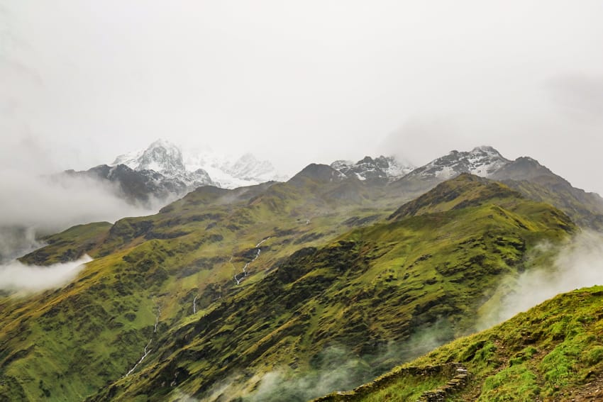
The Khopra Danda Trek is one of the lesser known treks in the Annapurna Conservation Area. In fact, until a few months ago, I had never even heard of it. Many people do Khopra Danda as an extension of the famous Poon Hill Trek or as a pilgrimage to Khayer Lake. It’s believed that a visit to Khayer Lake will grant the visitor one wish which makes it a popular destination for locals. This trek is not easy as it has an almost entirely uphill climb, but it’s one of the more beautiful treks I’ve done in Nepal. At the top, we found ourselves walking through fields of wildflowers which is a rare thing at an altitude of 3,600 meters. Here’s a few options for the Khopra Danda trekking itinerary.
Khopra Danda Trekking Map
Note: This map should not be used for navigational purposes. It is just meant to give an idea of the route. The trekking trail is not shown on most online maps including the one below and maps.me. That’s why it’s important to take a guide.
Khopra Danda Trekking Overview
Trek Duration
The Khopra Danda trekking trail takes 5 to 8 days depending on your itinerary and how much you’d like to walk versus taking a jeep.
Khopra Danda Difficulty Level
The Khopra Danda trekking route is surprisingly difficult considering how it doesn’t go above 4,000 m (12,000 ft). A large portion of the trek is completely uphill on steep slopes. The days are also long with over 4-5 hours of walking a day.
Required Permits
This trek requires an ACAP entry permit which costs 3,000 rupees (about $26 USD). You can get this permit at the Nepal Tourism Board office in Kathmandu or Pokhara. You will need your passport and two copies of your passport photo as well as cash when purchasing the permit.
Trek History
The Khopra Danda trekking route has been around for a while, however, it required camping previously. About 12 years ago (2009), the Khopra Community Lodge was started by the people of Paudwar and with a lodge available in Khopra Danda, the trek became more popular. This trek is still off-the-beaten path and is great for those who want to visit the Annapurna Conservation Area, but avoid the crowds. Avoiding the crowds is just one of the reasons to choose Khopra Danda.
Best Time to do the Khopra Danda Trek
Locals agree that October is the best time to do the trek for clear views. We went at the end of September and were hit with awful rainstorms that made it extremely difficult. I would not recommend even the end of monsoon for this trek. If you can’t go in October or November, the second best time of year is March or April.
Khopra Danda Altitude
3,660 m (11,811 feet)
Khopra Danda Trail Info
The trail for Khopra Danda is mostly uphill. Much of it runs through a jungle on a small dirt pathway. This is a proper trek. Most of the time, you are on a narrow local path that was not made specifically for tourists. I love this about this trek, but it is an adventure, and you should be prepared for tougher walking conditions. We walked through the jungle on a rainy day and it was difficult for us despite being regular trekkers with a lot of experience.
Navigating the Khopra Danda Trekking Route
The Khopra Danda trekking route is extremely difficult to navigate if you are coming from Ghorepani. Many of the trails are not listed on maps.me. We hired a local guide from Ghorepani after being told that the trail was not well maintained and that certain sections had bear sightings lately. We went at the end of monsoon and everything was overgrown. Even with a guide, we had to ask locals to point out the path. Therefore, I do not recommend doing this trek without a guide.
Khopra Danda Trekking Packing List
I have an entire post for my packing list as it was too long to include in this post. You can check it out here… Khopra Danda Packing List
Khopra Danda Trekking Costs
I also have an entire post dedicated to my budget and how much we spent on the trek. You can check it out here… Khopra Danda Cost
Khopra Danda Trekking Itinerary Options
Khopra Danda 5 Day Itinerary
The 5 day itinerary for Khopra Danda is extremely intense with constant uphill climbs, no rest days, and long walking days where you are on the move for more than 6 hours a day. Sometimes you are walking 8-9 hours a day. I do not recommend this itinerary unless you are in extremely good shape and are on a serious time crunch. I would not describe this itinerary as relaxing. It’s a tough workout which will push you.
Day 1 – Pokhara to Tikhedhunga by jeep. Then, walk to Ghorepani. (6 hours and 30 minutes walking time)
Check road conditions as sometimes there are landslides between Birethanti and Tikhedhungga and you may need to walk part of the way.
Day 2 – Sunrise hike to Poon Hill. Then, walk from Ghorepani to Upper Chistibang (Dhan Kharka) (8 hours walking time)
Day 3 – Upper Chistibang (Dhan Kharka) to Khopra Danda (2 hours 15 minute walking time)
Day 4 – Khopra Danda to Khayer Lake back to Khopra Danda (8 hours walking time)
Day 5 – Khopra Danda to Gharkholagaon and jeep back to Pokhara (7 hours 30 minutes walking time)
Khopra Danda 6 Day Itinerary
The six day Khopra Danda itinerary is still tough, however the first two days are broken up so that you can ease into the trek. The first day on most of the Khopra Danda trek itineraries requires an extremely long walk to Ghorepani which starts with a steep uphill. This itinerary breaks that up so that you don’t kill yourself on the first day. We did a variation of this itinerary (with some changes because of monsoon season) and it was difficult but manageable.
Day 1 – Pokhara to Tikhedhunga by jeep. Then, walk to Banthanti. (3 hours 30 mins walking time)
Check road conditions as sometimes there are landslides between Birethanti and Tikhedhungga and you may need to walk part of the way.
Day 2 – Walk from Banthanti to Ghorepani. (3 hours walking time)
Day 3 – Sunrise hike to Poon Hill. Then, walk from Ghorepani to Upper Chistibang (Dhan Kharka) (8 hours walking time)
Day 4 – Upper Chistibang (Dhan Kharka) to Khopra Danda (2 hours and 15 minutes walking time)
Day 5 – Khopra Danda to Khayer Lake and back to Khopra Danda (8 hours walking time)
Day 6 – Khopra Danda to Gharkholagaon and jeep back to Pokhara (7 hours 30 minutes walking time)
Khopra Danda 7 Day Itinerary
This is the itinerary I would recommend the most because it allows you a little time to breathe. I personally don’t enjoy walking for more than 6 hours a day even though I’m in good shape. As someone who treks often, I like to take my time and enjoy the trek without worrying about whether we will reach the village before it gets dark. Therefore, if you have the time, this is the most enjoyable trekking itinerary. It splits a few of the days into two and allows you to stay in some of the places that I thought would have made a nice stop. If you don’t like to sit still or stay at the teahouses for too long, then you should consider the 6 day itinerary. With this itinerary, you’ll likely have down time to read and play card games.
Day 1 – Pokhara to Tikhedhunga by jeep. Then, walk to Banthanti. (3 hours 30 minutes walking time)
Check road conditions as sometimes there are landslides between Birethanti and Tikhedhungga and you may need to walk part of the way.
Day 2 – Walk from Banthanti to Ghorepani. (3 hours walking time)
Day 3 – Sunrise hike to Poon Hill. Then walk from Ghorepani to Swanta (4 hours and 30 minutes walking time)
Day 4 – Swanta to Upper Chistibang (Dhan Kharka) (3 hours and 30 minutes walking time)
Day 5 – Upper Chistibang (Dhan Kharka) to Khopra Danda (2 hours and 15 minutes walking time)
Day 6 – Khopra Danda to Khayer Lake and back to Khopra Danda (8 hours walking time)
Day 7 – Khopra Danda to Gharkholagaon and jeep back to Pokhara (7 hours and 30 minutes walking time)
Khopra Danda 8 Day Itinerary
The eight day itinerary might be a little too easy or slow for some, but it’s great if you want a more leisurely experience. This allows you to stop in some cute towns and makes it so that you don’t have many long days of trekking. This is a better route for first time trekkers, people interested in experiencing the culture, those out of shape, or families.
Day 1 – Pokhara to Tikhedhunga by jeep. Then, walk to Banthanti. (3 hours and 30 minutes walking time)
Check road conditions as sometimes there are landslides between Birethanti and Tikhedhungga and you may need to walk part of the way.
Day 2 – Walk from Banthanti to Ghorepani. (3 hours walking time)
Day 3 – Sunrise hike to Poon Hill. Then walk from Ghorepani to Swanta (4 hours 30 minutes walking time)
Day 4 – Swanta to Upper Chistibang (Dhan Kharka) (3 hours and 30 minutes walking time)
Day 5 – Upper Chistibang (Dhan Kharka) to Khopra Danda (2 hours and 15 minute walking time)
Day 6 – Khopra Danda to Khayer Lake and back to Khopra Danda (8 hours walking time)
Day 7 – Khopra Danda to Paudwar (4 hours walking time)
Day 8 – Paudwar to Gharkholagaon and jeep back to Pokhara (3 hours and 30 minutes walking time)
Khopra Danda Trek – Detailed 7 Day Itinerary
Day 1 – Pokhara to Tikhedhunga to Banthanti
Tikhedhunga Altitude: 1,540 m (5,052 ft)
Banthanti Altitude: 2,210 m (7,250 ft)
Daily Altitude Increase: 670 m (2,198 ft)
Oxygen Concentration: 78% compared to 100% at sea level
Driving Time: 2-3 hours depending on the road conditions and time of year. We went in monsoon and were unable to take the jeep all the way because of landslides, however there are jeeps that run from Lamdawali all the way up to Ulleri. You just need to walk part of the way to get to them.
Walking Time: 2 hours and 30 minutes from Tikhedhungga to the top of Ulleri. 1 hour from Ulleri to Banthanti. Total time of 3 hours 30 minutes (not including lunch or tea breaks).
Distance: 3 km (1.9 miles) walking distance
Difficulty Level: Very Difficult
Teahouse: Mountain View Lodge in Banthanti
The walk from Tikhedhungga to Banthanti is difficult as it goes almost straight uphill. If you are going in the warmer months, it can be extremely hot because most of the trail is in direct sunlight with little shade from trees. It’s important to have enough water with you and good sunscreen. I’d also recommend some electrolytes to stay hydrated.
The good thing about this route is that there are tons of places to stop and rest along the way including many teahouses. The route is well maintained and the uphill sections are stairs made out of large rocks. The route up to Ulleri is the hardest. It’s slightly less steep going from the top of Ulleri to Banthanti.
Day 2 – Banthanti to Ghorepani
Banthanti Altitude: 2,210 m (7,250 ft)
Ghorepani Altitude: 2,880 m (9,448 ft)
Daily Altitude Increase: 670 m (2,198 ft)
Oxygen Concentration: 72% compared to 100% at sea level
Walking Time: 2 hours from Banthanti to Nangge Thanti. 1 hour from Nangge Thanti to Ghorepani. Total walking time of 3 hours (not including lunch or tea breaks).
Distance: 6.6km (4.1 miles)
Difficulty Level: Moderate
Teahouse: Nice View Lodge
Most people walk from Tikhedhungga to Ghorepani in one day, but it’s not at all enjoyable. Trust me, we tried it. Most of day two is a nice trail going through beautiful woods. You have protection from the sun and get to enjoy passing streams and listening to nature. It is longer in distance than day one but the uphills are not so steep and you can take your time walking it.
You’ll likely get to Ghorepani before lunch and have most of the day there to hang out. Ghorepani is a modern village with a lot of amenities like hot water, bookstores, small shops, and bakeries. You can take a hot shower, hang out and read a book while drinking a cappuccino. It’s not a bad place to spend a little extra time.
If you arrive early enough, you can even hike up to Poon Hill. This will allow you to make day three shorter, but it also gives you two shots at a clear view. Weather is unpredictable, so being able to go on day two or day three gives you a better chance at seeing the mountains.
Day 3 – Sunrise hike to Poon Hill, Ghorepani to Swanta
Ghorepani Altitude: 2,880 m (9,448 ft)
Poon Hill Altitude: 3,193 m (10,475 ft)
Swanta Altitude: 2,214 m (7,263 ft)
Daily Altitude Increase: 313 m (1,029 ft) up to Poon Hill
Oxygen Concentration: 78%(at Swanta) compared to 100% at sea level
Walking Time: 1 hour up to Poon Hill. 40 minutes down to Ghorepani. 2 hours and 45 minutes from Ghorepani to Swanta. Total of 4 hours and 25 minutes (not including breakfast, lunch, tea breaks, or time to take photos at Poon Hill)
Distance: 6.9 km (4.3 miles)
Difficulty Level: Moderate
Hotel: Hotel Candle Light
Typically, when trekking in Nepal, you go to viewpoints before the sun rises to ensure a better view as that is when the sky is most clear. This means leaving your teahouse around 4:30 am to climb to Poon Hill. The route is completely uphill on a stone path. You’ll get there around 5:30 am and have a half hour for photos and to see the sunrise (check the sunrise time with locals as it varies throughout the year). The entry fee to Poon Hill is 100 rupees and there is a teahouse at the top so bring cash with you.
After the sunrise, it takes about 30-40 minutes to come back down to Ghorepani where you can have breakfast. Make sure to order it the night before so that it’s ready when you arrive. You’ll be back to Ghorepani by 7:00 am.
After breakfast, you’ll begin the walk to Swanta. For some people this part may be easier as it goes downhill. My husband and I both hate downhills as it’s hard on our knees. Therefore, if you’re over 30 years old, I’d recommend considering trekking poles and knee braces especially for this section of the path. We went in monsoon when it had the added difficulty of being very slippery. You’ll be going down a steep downhill for about 1.5 hours. The cool thing about this section of the path is that you are walking through fields, farmland, and some dense jungle on a small path which feels like a proper trek. Up to Ghorepani is a well-traveled route, but now you are off-the-beaten-path taking the routes that locals walk.
Next you hit an uphill section which lasts about 1 hour until you hit the cute town of Swanta. I highly recommend Hotel Candle Light. The owner is incredibly sweet. Suraj had fallen and hurt his knee and she gave us some antibacterial medicine to take with us so we could treat the wound over the next few days. She also gave us some fresh vegetables to take to the next village since they had a shortage there. How nice is that?
This is the day that we needed a local guide. The path was extremely hard to navigate. There were no markings. Some of the trail had been destroyed in landslides making it hard to follow. Plus, the many local trails to get to people’s private homes looked the same as the trekking route and we found ourselves amazed that our guide knew which tiny trail was the one we wanted.
Day 4 – Swanta to Upper Chistibang (Dhan Kharka)
Swanta Altitude: 2,214 m (7,263 ft)
Upper Chistibang Altitude: 3,000 m (9,842 ft)
Daily Altitude Increase: 786 m (2,578 ft)
Oxygen Concentration: 71% compared to 100% at sea level
Walking Time: 3 hours and 30 minutes from Swanta to Upper Chistibang (not including tea breaks)
Distance: 4.82 km (3 miles)
Difficulty Level: Moderate
Hotel: Rockland Guesthouse
If you do this itinerary, day 4 will be an easy day. We actually went straight from Ghorepani to Upper Chistibang and it was difficult. In the last 40 minutes I had a meltdown and was crying. There were a few factors that went into this. For starters, we made the mistake of going in monsoon. It was pouring when we went and we were covered in leeches. No joke and not exaggerating, there was a point where we each had between 30 – 50 leeches on our clothes trying to find a way to get to our skin. We couldn’t stop walking because if you stopped, more leeches jumped on you. So, we power walked for almost 4 hours straight.
The problem with this route is that there is a steep ascent between Swanta and Khopra Danda. This means that if you went straight from Swanta up to Khopra Danda, you would likely get altitude sickness. So you need to spend a night in Upper Chistibang which is why I split this section up. Otherwise, you need to walk to Upper Chistibung from Ghorepani like we did, which is a long day.
The route from Swanta to Upper Chistibang is also hard to navigate. It starts out nice, going through fields, but soon it ends up in the jungle on a very steep incline. There were some major landslide zones when we had gone, and the trail was not well compacted which made it scary to cross. Upper Chistibang is a small village with only two teahouses. There was no electricity when we went, therefore you can take your time getting here. There’s no need to rush if you do this itinerary.
Day 5 – Upper Chistibang (Dhan Kharka) to Khopra Danda
Upper Chistibang Altitude: 3,000 m (9,842 ft)
Khopra Danda Altitude: 3,660 m (12,007 ft)
Daily Altitude Increase: 660 m (2,165 ft)
Oxygen Concentration: 65% compared to 100% at sea level
Walking Time: 2 hours and 15 minutes from Upper Chistibang to Khopra Danda (not including breaks)
Distance: 3.05 km (1.9 miles)
Difficulty Level: Easy
Hotel: Khopra Community Lodge
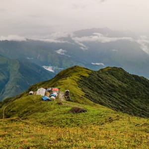
The walk to Khopra Danda was by far my favorite. First, it didn’t feel like 2 hours. I thought we were only walking for about an hour when we arrived. Second, it’s one of the most beautiful areas I’ve walked through on a high altitude trek. It was a rainy morning with clouds completely blocking our view and still I loved this section of the trail. The mountain was overgrown with so many varieties of wildflowers that I was completely blown away. I can only imagine how gorgeous it must be on a clear day when you can see the mountains.
The path starts out steep, but after a little while it evens out and it’s a steady incline to Khopra on a path that winds around the mountain cliffs. There’s a small temple along the way where you can leave an offering of flowers for the gods. Overall, this day is an absolute treat.
Day 6 – Khopra Danda to Khayer Lake and back to Khopra Danda
Khopra Danda Altitude: 3,660 m (12,007 ft)
Khayer Lake Altitude: 4,660 m (15,288 ft)
Daily Altitude Increase: 1000 m (3,280 ft)
Oxygen Concentration: 58%(at Khayer Lake) compared to 100% at sea level
Walking Time: 5 hours up to Khayer Lake. 3 hours down to Khopra Danda. Total walking time 8 hours (not including breaks or time to take photos at Khayer Lake)
Distance: 16.09 km (10 miles)
Difficulty Level: Very Difficult
Hotel: Khopra Community Lodge
Unfortunately, we were hit with an awful storm at Khopra Danda. We tried to wait it out for a couple of days, but the clouds barely lifted. The winds were so strong that it sounded like the roof of the teahouse was going to rip off and we were told it was too dangerous to walk to the lake. We had a few moments when the clouds lifted and we could see the mountains, but with an 8 hour trek ahead, the weather was never clear enough to move forward.
The trip to the lake takes 5 hours and it’s about 3 hours back down. There is a small tea shop there, however, it isn’t always open and it only makes a few simple items like ramen noodles. Therefore, it’s best to ask the local teahouse owners if you should bring food with you on this day. It’s believed that those who visit the lake are granted one wish, so think about what to wish for when you arrive.
Day 7 – Khopra Danda to Gharkholagaon and drive to Pokhara
Khopra Danda Altitude: 3,660 m (12,007 ft)
Gharkholagaon Altitude: 1,170 m (3,838 ft)
Daily Altitude Increase: -2,490 m (8,169 ft) to Gharkholagaon
Oxygen Concentration: 88% compared to 100% at sea level
Walking Time: 4 hours from Khopra Danda to Paudwar. 3 hours and 30 mins to Gharkholagaon. 2 hours’ drive to Pokhara. Total walking time 7 hours and 30 mins (not including lunch or tea breaks).
Difficulty Level: Difficult
Day 7 is another long day which is why I like this itinerary. Splitting up some of the earlier days helps make the last few days easier. If you have extra time, you can follow the 8 day itinerary which splits this day into two and allows you an overnight stay at Paudwar village which is beautiful. We did it all in one day and it was long, but we had two rest days in Khopra Danda while waiting for the weather to clear.
The walk to Paudwar is a steep downhill, but it’s gorgeous. Again, you are surrounded by incredible wildflowers of every shape, size and color. This section also had some wildlife sightings! Our guide was great at spotting animals that we would have missed. We saw a mountain mouse, deer standing on the cliffs, and some very interesting birds.
After an hour, you end up walking through the forest. This portion of the route is well marked and easier to navigate. It’s a wide path and a lot of it has been made with stone. This leads to the village of Paudwar which is a gorgeous old town made of stone buildings and winding alleyways.
After Paudwar, we took a slightly different route that went towards Shikha which is south of Gharkholagaon. We were told the area had a lot of bears, so I don’t recommend walking in the area below Paudwar by yourself. It’s better to go in a group. We had planned to do another trek so we took a slightly different route, however, I’m told it would take about three and a half hours to get to the main highway by Gharkholagaon. If you want, you can get a bus or jeep from there. You can also spend a night there if you arrive too late and want to rest and take a jeep in the morning.
Khopra Danda Village Guides
Have more questions about my Khopra Danda trekking itinerary? Ask in the comments.
You might also like…
Michelle Della Giovanna
Writer at Full Time Explorer
I’m just your average New Yorker who quit her job in the fashion industry to explore the world. Come find out what it’s like to trade in five-inch heels for squat toilets.
Leave a Reply